Posts

North-West Highlands a landscape aesthetically carved by geology

Image
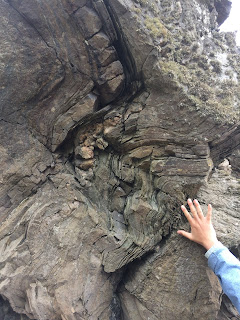
North west highland is located at one of the ancient coast close to the Atlantic and Loch Gleann dubh. Before we dive into the great geologic history that this place offers, I would like to talk about couple things that happened at the time.Our day started as we checked out of Portress hostel, we neatly packed our belonging into our vans and drove for more than 3 hours to Loch Assynt and Archmore duplex for the field.  I took this picture across the road as we were observing this amazing rock units The site is quite famous for the geologic mapping amongst the British students as we ran into a large group of geology student that were doing excursion in the same area. Well you may wonder if any of us broke out of their shell and perhaps said something or stroke a sustainable conversation with the other side other than the usual glances and nodding perhaps(at least for some people). I would say that I saw few people from both sides did make a notable effort to find out what the

the last post from Scotland 2018

Image
The last three sites we visited are each interesting for their scientific variety and historic context: Just North of Stonehaven we explored Barrow's metamorphic isograds (biotite in, garnet in, staurolite in) within just over 1 km on Pertumie Bay. The reason this change in petrology occurs on such short distance is due to movement along the Highland Boundary Fault which we visited just to the South at Creageven Bay.  (fold structures at the North end of Pethumie Bay where we also found staurolite) (view SE across Creageven Bay and along strike of the Highland Boundary Fault which juxtaposes rocks of the Highland Border Complex on the left with Dalradian metamorphic rocks on the right) Siccar Point is probably the most famous geology outcrop on this planet; it is here that James Hutton found proof for the idea of deep geologic time. Red Devonian sandstones rest unconformably on near vertical Silurian sedimentary rocks. (measuring strike and dip of the two units
Image
JUNE 02/2018 - SHETLAND ISLAND Hello Geo folks, Today the Capstone crew was in Shetland Island, studying the Shetland ophiolite. An ophiolite is a part of an oceanic crust that has been thrusted onto the continental crust, through a process called obduction. Shetland ophiolite was formed during the Ordovician period (480 million years ago) when the Iapetus ocean closed. The team drove to Unst where the ophiolite is well exposed. As the team approached the outcrop, a herd of ponies, came running, hoping to be fed with snacks.           A  beautiful moment of human-animal            interaction. The friendly ponies followed the team around as the team was trying to identify the ophiolite from the surrounding rocks and, according to Michael Rego, they were helping in identifying the ophiolite (jokes folks). It wasn’t long before Ivano identified the boundary between dunite and harzburgite rocks which signifies the Mohorovicic discontinuity.            

Geologic Structures, Joy's Glasses and Harry Potter

Image
Hello again, On our way to Skye we saw great geologic structures, the Harry Potter train and Vasa drove a lot. I’ll begin with the geology, since we are on a geology fieldtrip. We went to an outcrop called Muidhe  led by Chantel. The first thing noticed was the rounded peaks on the outcrop. Most students had an idea of the geologic history of Scotland and knew about the previous glaciations in the area. We took a closer look at the rocks saw some roche moutonnĂ©e further solidifying our initial hypothesis about the glacier erosion in the area. The U-shaped valley as well as the pattern seen with the roche moutonnĂ©e helped us determine the glacier was running north west. In addition to the glacier erosion we saw a lot of folding within the igneous and metamorphic rocks. The metamorphic rocks are part of the Glenfinnan group which include psammites and pelite. It was easy to see the more dominant layer that shaped the folds and the more brittle layer. There were some pegmatit

Isle of Skye I

Image
Having finally arrived in the much anticipated Isle of Skye, we began our first day with high expectations (which, spoiler alert, were certainly met). The weather was overcast and foggy, lending an eery beauty to our surroundings. We drove north along the eastern coast, from our bright yellow hostel in Portree, to Kilt Rock, a fantastic exposure of Jurassic sediments topped with columnar dolerite (compositionally equivalent to basalt and gabbro, but with a grain size intermediate between the two). These columns give a "pleated" appearance to the rock (like a kilt), hence its name. View of Kilt Rock (once the fog finally cleared) Sketch of Kilt Rock (Note Credit: Caroline Lee, Photo Credit: Charly Bank) Another short drive along the coast took us to spectacular sauropod footprints, some expressed as depressions in the shale, and others preserved as casts. The footprints we saw, large as they were, may have been smaller than the sauropod's actual fee

Orkney

Image
   We were on the road bright and early for our drive from Gairloch in the North West to Orkney, the closer of Scotland's Northern Isles. The foggy drive brought us to the Ferry, where we had the choice of a nap, a snack, and as we got closer to land, a view of Orkney's beautiful sea cliffs. This interesting feature is formed by the erosion of the sandstone cliff side along preexisting weaknesses in the rocks. A natural arch forms, and once it collapses a tall solitary stack remains.  Old Man of Hoy    Just before the Old Man of Hoy, a couple of students and Vasa ran excitedly across the deck of the ferry. They say they saw a dolphin, but without photos I suppose we'll never know for sure!   Once we reached the island, we found our hostel and called it a night. For our one and only full day on Orkney, we had three goals: Explore the rich Archeology Admire the beautiful coastal geology Enjoy a distillery tour and have a Scotch    Archeological

Isle of Skye II

Image
Hi everyone! Today was our second and last day on the Isle of Skye, and perhaps the most challenging and yet rewarding day of our trip thus far. In the morning we visited the remains of a magma chamber, and in the afternoon we embarked on a difficult hike up to a cirque on Glen Brittle. After a quick breakfast, we all piled into the vans and drove toward the ferry that would take us to the chamber located on the south side of Skye. The magma chamber is located in the Black Cuillin hills, which experience less weathering than their neighbouring Red Cuillin hills. This is because the Red Cuillin’s are composed of granites which weather into clays and are therefore more susceptible to erosion by glaciers. With high spirits, we enjoyed a fun ferry ride, taking in the beautiful scenery and the wildlife such as the seals pictured below. After disembarking the ferry, we walked toward the center of the magma chamber, noting that there was abundant peridotite along the trail. The cen